Brett

What I Did To Prep This Week – Week 72: November 24th 2019 – November 30th 2019

Happy Thanksgiving, Pack! I hope you enjoyed a bountiful dinner and the loving company of family and friends. Approximately one minute after the Thanksgiving turkey is served each year the grandkiddos become allowed to sign Christmas songs. Doing so before the November holiday always costs them a Christmas present. Christmas is my favorite time of year – well, it is actually tied with the…

Source

What I Did To Prep This Week – Week 72: November 24th 2019 – November 30th 2019 Read More »

5 Gray Man secrets I learned as a surveillance operative

The gray man concept isn’t a difficult idea but isn’t as easy as just trying to be invisible. I broken down some of the basic secrets I learned about how to hide in plain sight during

You’re reading 5 Gray Man secrets I learned as a surveillance operative, originally posted at Graywolf Survival – Emergency preparedness from a Counterintelligence Agent by Graywolf.

5 Gray Man secrets I learned as a surveillance operative Read More »

Beyond L.A.: Three waterfalls in the Catskills (Upstate New York)

Long before the Catskill Mountains of New York State became known as the Borscht Belt, glacial snowmelt from the Ice Age was carving streams and canyons through the region. Numerous waterfalls were created as a result of this activity. This edition of Beyond L.A. spotlights Kaaterskill Fallls, the highest waterfall in the state (including Niagara) and two less known but also exciting destinations: Vernooy Kill Falls and Stony Kill Falls. (“Kill” means “creek” in Dutch). Kaaterskill Falls and Vernooy Kill Falls are located in Catskills Park, an area thought of as one entity but in fact overseen by multiple agencies (similar to the Santa Monica Mountains). Stony Kill Falls is located in Minnewaska State Park Preserve.

TIPS FOR L.A. HIKERS

Getting to the Catskills: These hikes are located between 110 and 140 miles north of New York City; a 2.5-3 hour drive depending on traffic. JFK International Airport in Queens (JFK) will have the most options for flights in and out. Newark, NJ (EWR) and New York LaGuardia (LGA) are also options. The hikes are slightly closer to Albany (between 50-80 miles south, or a 1.5-2 hour drive) but the airport (ALB) has fewer options for flights.

Staying in the Catskills: None of these hikes allow overnight camping. For information about accommodations in the Catskills and greater Hudson Valley, click here and here.

Weather: The weather in the Catskills ranges from an average daily low of 19 degrees F/-8 degrees C in January to an average daily high of 82 degrees F/29 degrees C in July. Average annual precipitation is 48 inches, about three times that of Los Angeles. In the winter months, these trails may close due to hazardous conditions from snow and ice.

Cell phone reception: Cell phone reception is weak to fair on the Vernooy Kill Falls and Stony Kill Falls hike. There is no reception at the Kaaterskill Falls trail head or on the hike itself. If you are coming from the east, the last reliable cell phone reception will likely be in the town of Palenville, about five miles away; from the west, it will be Haines Falls, about three miles away.

Dogs are allowed on leash on these hikes. Some dogs might have difficulty with the steep stair climbs and extra caution should be taken both in summer heat and in winter conditions. All three of these trails, especially Kaaterskill Falls, are popular, so expect to see other dogs, especially on summer weekends. Kaaterskill Falls begins and ends with a quarter mile walk along the side of Route 23A (no sidewalk or shoulder).

THE HIKES

Kaaterskill Falls

2.8 miles, approximately 800 feet of elevation gain; allow 2 hours

While it might not be one of the most popular destinations in the United States as it once was, Kaaterskill Falls still sees many visitors. This write-up assumes a start from the lower and most popular trail head on Route 23A, but the falls can also be visited by starting above from Laurel House or Scutt Road. For a map of all of the trail heads and trails in the area of Kaaterskill Wild Forest, click here.

From the parking area, head downhill on route 23A. There is no sidewalk or shoulder, although a metal railing on the north side of the road provides a buffer. Many of the cars are likely to be hikers heading to or from the trailhead, so they will go slowly and give a wide berth.

The official trail begins one quarter mile from the parking lot. You are greeted by Bastion Falls, itself an impressive cascade that would probably considered a worthy hiking destination were it located more remotely. The trail climbs steeply, picking up almost 200 feet in the first 0.2 mile, before leveling out. The next 0.2 mile climb more gradually, ascending about 100 feet. Downed trees may block the route in some spots; look for the yellow trail blazes for the route, which closely follows the banks of the creek.

Soon the lower tier comes into view. Hikers with small kids might be content to work their way across the rocks to the base of the falls, where both tiers are visible but for those with the energy for a steep climb, the ascent to the viewing deck at the top of the falls is well worth it. Begin the next leg of the hike by following the stairs up the side of the canyon, gaining almost 200 feet in only 0.1 mile. On the way up, a spur leads to the base of the upper tier.

After making the steep ascent, the trail becomes level, heading southwest and away from the falls before doubling back. After reaching an intersection with the trail from Scutt Road, turn left and cross the creek on a footbridge. On the opposite side, the trail from Laurel House comes in on the right. Continue straight ahead and follow the signs to the viewing platform. If you are looking to overcome a fear of heights, you have come to the right place.

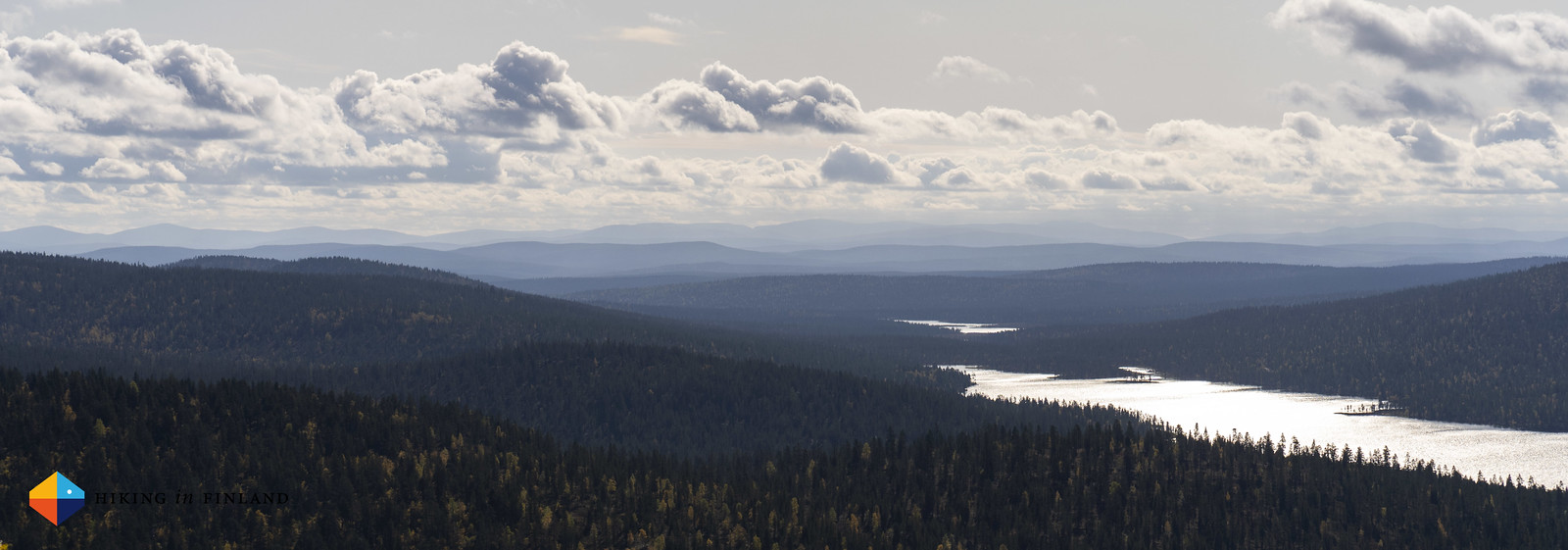
From the small wooden deck, you can see the length of Kaaterskill’s 167-foot upper tier plus an excellent view of the distant mountains. After enjoying the vistas, retrace your steps, exercising caution on the steep descent.

For more trip reports of Kaaterskill Falls, click here, here, here, here and here. For cautionary tales about Instagram posts at Kaaterskill Falls that didn’t go as planned, click here.

Plaque in the parking lot on Route 23A

Bastion Falls

Following the creek

View from the bottom of the lower tier

(How badly do you want that selfie?)

View from the base of the upper tier

View of the stairs from the platform at the top of the falls

Mountain view from the platform

Stony Kill Falls

1.6 miles, approximately 250 feet of elevation gain; allow 1 hour

Located in Minnewaska State Park Preserve, 87-foot Stony Kill falls is another essential Catskills hike. The base of the waterfall can be reached via an easy half-mile stroll. Hikers who want more of a challenge – and an outstanding view – can climb to a viewing area at the top of the falls.

The hike starts rather anonymously with 0.3 miles of walking along Shaft Road to the official start of the trail. The trail dips into the woods, following the creek for a quarter mile to arrive at the base of Stony Kill Falls. A footbridge provides the best vantage point for legally viewing the falls from below.

The red-blazed trail climbs steeply from the base of the falls. At one point, metal rungs are embedded in the rocks to provide hand and footholds. At the top of the stairs, your efforts are rewarded with an outstanding view of the valley below and of the upper end of the falls. There is no guard rail.

This spot, about 0.7 mile from the trail head, is a good turnaround point, but for those who like to see things to their completion, the trail continues another tenth of a mile along Stony Kill. Since most people stop at the view point, this last stretch will give you some solitude. At the end, you can wander down to the creek bank and enjoy the peacefulness before retracing your steps.

For more trip reports of Stony Kill Falls, click here, here and here.

Start of the hike to Stony Kill Falls

Stony Kill Falls as seen from the footbridge

Side view of Stony Kill Falls

Climbing the stairs to the view point

Rungs on the Stony Kill trail

View of the top of Stony Kill Falls

View from the top of Stony Kill Falls

Stony Kill above the falls (turnaround point)

Vernooy Kill Falls

3.2 miles, approximately 650 feet of elevation gain; allow 2 hours

Though it doesn’t have the height of Stony Kills or Kaaterskill, Vernooy Kill Falls is an enjoyable hiking destination. The trail is more lightly visited than the other two and travels through some attractive woodlands en route to the stair steps-shaped waterfall, which drops about 20 feet over multiple tiers. Vernooy Kill Falls is located in the Sundown Wild Forest area of Catskills Park.

From the parking area, cross the street and begin hiking on the blue-blazed trail (signed as the Long Path on some maps). You cross a creek on a footbridge at about a quarter mile and begin a steady but moderate ascent through mixed forest. Half a mile from the start, your route merges with another trail; continue straight and follow the blue blazes. At 1.2 miles, you reach the high point of the hike and begin a slow descent. Just before you reach the falls, look for the remains of a campsite on your left.

At 1.6 miles, you reach a junction. The routes to the right and straight ahead lead deeper into Sundown Wild Forest, options if you want to extend the hike. The left fork leads to a footbridge overlooking Vernooy Kill Falls. It is possible to scramble down to the bank of the creek for a closer look, although caution is essential on the slippery rocks. The trail continues another 2 miles to county road 46 near the town of Greenville.

For more descriptions of Vernooy Kill Falls, click here, here and here.

Start of the hike to Vernooy Kill Falls

Footbridge over Vernooy Kill

Vernooy Kill as seen from the footbridge

Fall colors, Vernooy Kill

Vernloy Kill Falls as seen from the footbridge

Looking downstream from Vernooy Kill Falls

Lower tier of Vernooy Kill Falls dropping under the footbridge

Side view of Vernooy Kill Falls

Text and photography copyright 2019 by David W. Lockeretz, all rights reserved. Information and opinions provided are kept current to the best of the author’s ability. All readers hike at their own risk, and should be aware of the possible dangers of hiking, walking and other outdoor activities. By reading this, you agree not to hold the author or publisher of the content on this web site responsible for any injuries or inconveniences that may result from hiking on this trail. Check the informational links provided for up to date trail condition information.


Beyond L.A.: Three waterfalls in the Catskills (Upstate New York) Read More »

OFFGRID Whiskey Gift Guide: A Gift Guide for Men Who Love Whiskey

OFFGRID Whiskey Gift Guide: A Gift Guide for Men Who Love Whiskey

From Texas to Scotland, we are going to take you around the world and share some of our favorite Whiskey, Scotch, and Whiskey related gifts… […]

This Article OFFGRID Whiskey Gift Guide: A Gift Guide for Men Who Love Whiskey is an original article from OFFGRID Survival If it is appearing on any other site but OFFGRID Survival, that site does not have our permission to use our copyrighted content!

OFFGRID Whiskey Gift Guide: A Gift Guide for Men Who Love Whiskey Read More »

Mountainbiking in Saariselkä, Lapland

Exploring the fjells by bike, hollering with happiness as we ride down the beautiful singletrails. Mountainbiking in Lapland in the autumn is a unique and beautiful activity, and with many trails available you can go off adventuring by bike for many days!

On the way to the Singletrail

Disclosure: This trip was supported financially by the Arctic Outdoor project. As you know: I’m keepin’ it real and tell you how it is – I maintain full editorial control of the content published on Hiking in Finland. Read the Transparency Disclaimer for more information on affiliate links & blogger transparency.

I’m a cyclist, and on my backpacking and work trips riding my bike is one of the few things I miss. I like the speed, the new perspective on things, the ability to see more in a shorter amount of time. It’s great, fun, too! So when I saw that one of my Polarlife Outdoors activities would be to go ride Mountainbike in the fjells, I was really happy and excited. Last year in Åre I learned to ride downhill mountainbiking and I have looked forward to another opportunity to ride a bike in the hills of Lapland.

The forecast for the day was grey and rainy, but tht did not dampen my spirit. I met up with Reima & Tiina from Saariselkä Training and Anni at the bike shed, where we got our bikes, and then we were altogether off to the hills!

MTB with Saariselkä Training

Amazing views

Now this was not a downhill ride. We powered up the fjell with our own power (no eBike or gondola!) and rode from wide, easy paths over swampy duckboard sections to a very short stoney trail to the summit on many different kinds of terrain, which is excellent for beginners like me. That way the trail got a little more demanding the higher we got, and once at the summit it was wide views, happy high-fives, and getting excited about the downhill ride.

On the way to the summit

Summit Selfie

Enjoying the view

As these things tend to go, by the time we rolled towards the single trail the weather decided it was time for a bit more moisture, and so a light drizzle started to accompany us on our way down. This did not curb our enthusiasm for the singletrail, though! Reima and Tiina were shredding fast down their home trails, and I was hollering with joy in the beautiful nature!

Faster!

Jump around!

After a way too short section of easy downhill singletrail Tiina & Reima guided us on gorgeous paths through the autumnal forest. Pine needles from many years made these trails soft and enjoyable, with little curves, small ups & downs, and around us the forest with all the beautiful colours of red, orange, yellow and green.

Autumn MTB colours

Orange. Yellow.

Ride.

Riding in the Rain

Sadly also this delightful forest ride was over too quickly, as we arrived at a cozy Kota, where Reima brewed us a fine coffee and and we ate some home-made cake. This is such a nice touch, eating real, home-made food outdoors, and drinking good coffee, and in hindsight it seemed to be a unifying thing between all the Polarlife Outdoors activities I did that week: Tasty food, prepared at home, enjoyed with kind people, in nature.

Breakie at a Kota

Hei Hei

We chatted about cycling, the outdoors and life in the North during our coffee break, and then saddled our bikes for a final time as we had a short ride back to the village in front of us. We continued our chats on the bike, and it made me want to go for another mountainbike trip here with these two in the beautiful nature of Lapland. Reima and Tiina were excellent guides, very calm, friendly and down-to-earth – I really enjoyed spending time with them, riding in and around the woods & hills of the Urho Kekkonen National Park, and I hope to ride again with them the next time I visit Saariselkä ????

Read about the other Polarlife Outdoors activities I did, like preparing Wild Foods in the forest and hiking to the Akupää summit!

MUD

Practicalities!

I stayed in Saariselkä, which is probably THE place to be when you want to explore the North-Eastern corner of Finnish Lapland. Besides a dozen or more options for accommodation options – I stayed at the Lapland Hotels Riekonlinna‎ – the village lays right at the border of the Urho Kekkonen National Park and is just a short 2 hour stroll away from the Hammastunturi Wilderness Area. This means you don’t need a car to go outdoors in Saariselkä, as you can walk in a few minutes from your Hotel or log cabin to the start of a trail. Here’s the full list of Hotels and Cabins in Saariselkä, and feel free to use that Affiliate Link when you’re making a reservation!

Lapland Hotels Riekonlinna Room

Getting to Saariselkä happens in one of three ways: You drive your car north for a veeeeeeery long time but are mobile there. Useful if you want to drive to different places, but hopefully you’re not alone in that car! The second and best option is to take the train and Bus. Taking the Bus from Rovaniemi to Saariselkä is a short and scenic 3 hour ride, and it really gets you in the mood for the outdoors as you ride past lakes and forests and every so often slow down to let the Reindeer get off the road. Taking an (overnight) train to Rovaniemi from Southern Finland is also very convenient, as you wake up well rested and just a short ride away from your next outdoor adventure. This is also a good way to travel if you want to explore Helsinki before or after a visit in Lapland. Finally, if you come from abroad you also can fly directly to Ivalo, from where you can take a bus or Taxi to Saariselkä.

Oulu - Tromso

Saariselkä has for a village its size a variety of different options for eating out, from Anne’s Garden which serves delicious Burgers (great for backpackers who just returned to civilization!) to fine dining at Santa’s Hotel Tunturi and Lapland Hotels Riekonlinna‎ or the tasty Buffet at the Holiday Club. Cafe Porotupa at the market square makes really good coffee (On a side note, I’m always baffled how much bad coffee you get served in a variety of places in Finland, the World Champion in coffee consumption) and also fresh pancakes and cakes. If you rather cook yourself, then the supermarket in the village has everything you need, or if you need to stock-up on dehydrated meals for another backpacking trip then visit the Partioaitta Saariselkä, probably the most-northern Outdoor Store in Finland!

Starter at Santa's Hotel Tunturi

Love me some bread

During my visit at Saariselkä I participated in many different Polarlife Outdoors activities, include going to the Sauna and Spa at the Holiday Club, hiking on one of the dozen of trails around the village, visiting the AMAZING Aurora Open Wilderness Hut when you want to see Northern Lights, participate in a wild herbs Workshop, visit a Sauna and going to swim in a stream, or rent a Mountainbike and explore one of the many single track trails and holler with joy when you ride down the fjell! During the next weeks you’ll be able to read more about my adventures in the far north and some of these activities, so consider becoming a Fan on Facebook or Twitter to not miss the next instalments!

Aroma Sauna at Holiday Club Saariselkä

Aurora Hut in Saariselkä

Taking a dip in the Sauna Stream at Wilderness Hotel Muotka

Support me on Patreon and get some useful rewards (like hanging out on Discord with me, and Discount codes for kit from partners!) or buy me a coffee – I work Full-Time on Hiking in Finland to bring you inspiring trip reports, in-depth gear reviews and the latest news from the outdoors. You also could subscribe to the rarer-than-ever Newsletter and follow along on Instagram, Twitter, Facebook and Youtube for more outdoorsy updates!

16:9

Mountainbiking in Saariselkä, Lapland Read More »

Growing Marshmallow for its Soothing and Healing Properties

A Guest Blog Post by ELLE MEAGER

Marshmallow is part of the Mallow (Malvaceae) family. The name
“Malvaceae” means “soft” and “to heal”, which gives you a pretty good clue
as to what its benefits are. Marshmallow’s Latin name, Althea officinalis, has
important meaning as well. “Althea” comes from “altho”, which means “to cure”.

This herb is an incredibly useful plant to grow in your garden, as it is an anti-inflammatory, antiseptic, and emollient, among other things. It is known as a survival food, due to its hardiness and availability when other crops have died.

How to Grow Marshmallow

Marshmallow is a perennial, so no need to re-sow every year. It
grows between 2 and 4 feet tall, with velvety soft leaves. They are deciduous
and may die down to ground level in winter, then reshoot in spring.

If you want to propagate some more free Marshmallow plants (and
we should all have quite a few in our gardens!), divide the roots up just when
it starts to wake up and re-shoot, in early spring. You can propagate from
cuttings also, in late spring and summer.

Marshmallow will grow in a wide range of climates (zones three to nine) in anything from sandy soil to very wet soil (as its name “marsh”mallow implies!). It’s salt tolerant for gardens near the sea and can handle a fair amount of drought.

How to Use Marshmallow

We’ll make Marshmallow tea and Marshmallow poultice. The main
benefit of Marshmallow, in my opinion, is its soothing action. It will soothe
anything! Skin, throats, intestines, urinary tract, any inflammation…

This soothing action comes from its mucilage content, which is 25-35% in the roots and 10-20% in the leaves. It also contains asparagine, which is a powerful natural pain-reliever.

Making Marshmallow Tea

You can make Marshmallow tea as a hot infusion or a cold
infusion. Drink this to soothe colds, to battle inflammation, to stimulate your
immune system, to wash sore eyes, and soothe skin allergy or insect bites. Rinsing
wounds with Marshmallow infusion has an antiseptic and healing effect.

For a hot infusion:

  1. Take
    2 teaspoons of dried herb or 4 teaspoons of finely cut fresh herb.
  2. Pour
    1 cup of boiling water over the top.
  3. Leave
    it to steep for up to 10 minutes.
  4. Slowly
    sip one to three cups for day.

For a cold infusion:

  1. Take 2 teaspoons of dried herb or 4 teaspoons of finely cut fresh herb.
  2. Pour 1 cup of cold water over the top.
  3. Leave it to steep overnight.
  4. Warm it slightly before drinking.
  5. Slowly sip one to three cups per day.

Making a Marshmallow Compress

A Marshmallow compress is one of the most soothing remedies I’ve
found for wounds and other skin conditions. It is exceptional at soothing
sunburn, bruises, irritation, skin rash, and drawing out boils or inflammation.

  1. Take
    1 cup of dried herb or 2 cups of fresh herb.
  2. Finely
    chop it or pulse it in a blender.
  3. Add
    a small amount of water, just enough to create a gel.
  4. Put
    it directly on the skin and bandage it up, or put the gel on some gauze and
    apply to the skin before bandaging.
  5. You
    can leave this for a few hours or overnight, after which you can re-apply new
    poultice if needed.

For extra drawing power (like for pimples, boils, etc.) add a
small amount of kaolin clay. For extra healing power for the skin, add a small
amount of zinc oxide powder (non-nano particles). For extra skin moisturising
properties, add a small amount of glycerin.

I always keep frozen cubes of Marshmallow poultice in the freezer, so I can pull one out when the kids have a cut, bruise, insect bite, scrapes… It’s extra soothing when it’s icy cold and very convenient when they’re ready to go in the freezer.

What Else Can We Do With Marshmallow?

Marshmallow is a useful survival food. Grow some and you’ll never
run out of food! Eat leaves and flowers raw in a salad. Chew the leaves raw, on
their own, for a good amount of vitamin A or to soothe a dry mouth. Add some
leaves to soups, pickles, or stews. Eat the young roots steamed or cooked.

And of course, make your own natural marshmallows from the roots!
These days, marshmallows are made with gelatine and sugar, but why not bring
back the original marshmallow and eat some sweets infused with goodness?

Elle Meager is passionate about turning every backyard into a self-sufficient edible garden and herbal medicine cabinet. She is the founder of Outdoor Happens (https://www.outdoorhappens.com)

The post Growing Marshmallow for its Soothing and Healing Properties appeared first on WillowHavenOutdoor Survival Skills.

Growing Marshmallow for its Soothing and Healing Properties Read More »