I have been very lucky to spend a lot of time doing hikes in Canada – across all provinces and territories. What I look for in a great day hike is superlative scenery – with my preference being coast, lake or mountain views or even something that makes the hike unique. The Mingan with its fantastic eroded rock monoliths would be a great example. I’m not a fan of hiking miles through forests without a view.
From decades of hiking I think these are 35 of the greatest day hikes in Canada. Granted it’s a subjective list and many noteworthy hikes are missing. At the bottom of the post I have included hikes that I also recommend or still hope to do.
Please note that these are day hikes in Canada – not multi-day hikes. Some are short and very family-friendly while others can get into the epic category. I have tried to offer some variety geographically so as an example, not all hikes in Alberta are in Banff and Jasper National Parks.
I have also not included backpacking trips here but you could read this post – 37 Long Distance and Backpacking Trails in Canada.
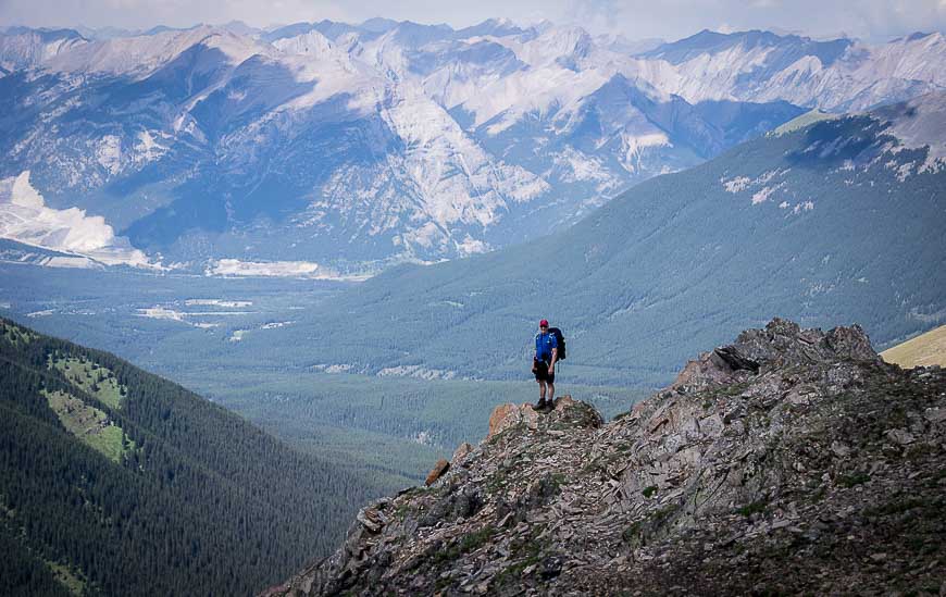
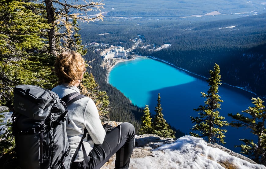
John enjoying an airy view from the Mount Allan summit in Kananaskis Country
Yukon Day Hikes
Auriol Trail, Kluane National Park
This is an easy hike with a trailhead close to Haines Junction. In short order you’re rewarded with wildflowers (in season) and gorgeous alpine scenery. Allow three to five hours to cover the 15 kilometres with an elevation gain of just 397 metres. There is a rustic campsite at the turnaround point.
Read: Hiking the Auriol Trail in Kluane National Park
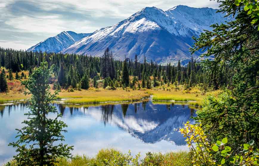
Spectacular scenery on the Auriol Trail
Goldensides Trail, Tombstone Territorial Park
The hike starts at the 74.5 KM sign on the Dempster Highway, only a 10 minute drive north of the Interpretive Centre. This is a great family-friendly hike or for anyone who wants to stretch their legs while driving the Dempster Highway. It’s all of 3.4 kilometres round-trip with a vertical gain of 210 metres. Allow 90 minutes.
If you’re looking for an epic all day hike nearby I highly recommend Grizzly Lake though I think it’s better done as a backpacking trip.
Read: The Goldensides Hike in Tombstone Territorial Park
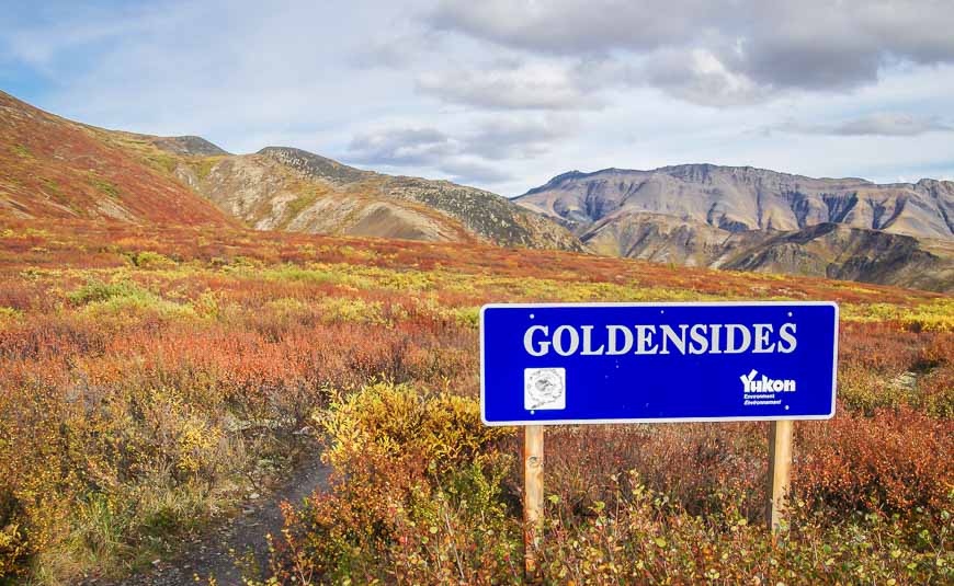
The start of the Goldensides hike in Tombstone Territorial Park
British Columbia day hikes
Coast Trail, East Sooke Regional Park
If you don’t have time to do the West Coast or Juan de Fuca Trails, spend a day hiking 10 kilometres one way on the Coast Trail. Don’t turn up your nose at its length.
Like all coastal trails, this one is way harder than you’d expect. Allow 5-6 hours one way. If you can’t arrange a shuttle do it as an out and back, going as far as you have time. Enjoy wonderful coastal views, massive trees and wildflowers.
Read: A Hike on the Coastal Trail in East Sooke Park, BC
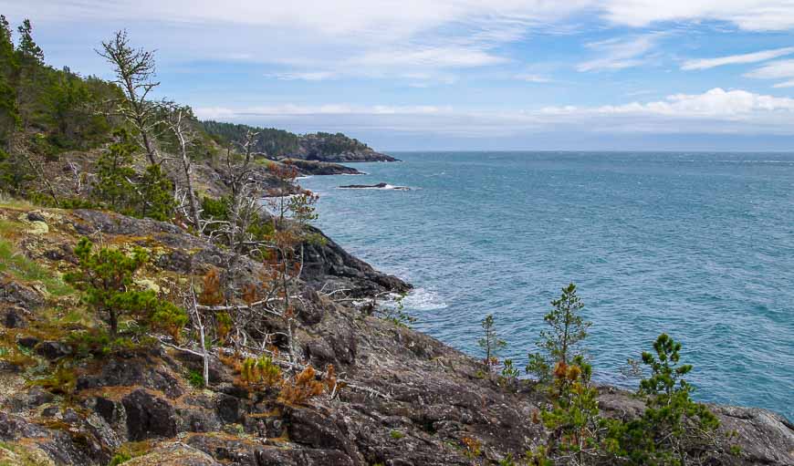
Coastal views at the northern end of the trail
Black Tusk, Garibaldi Provincial Park – one of the longer day hikes in Canada
Plan on a full day if you want to summit the Black Tusk – or even if you want to go as far as its top flank. Its 29 kilometres return from the Rubble Lake parking lots – and there’s a lot of elevation gain – 1,735 metres. Allow a solid 8 – 10 hours and go well-prepared.
The reward apart from the spectacular views at the top are high alpine meadows, great views of Garibaldi Lake and loads of wildflowers.
Read: A Hike to the Black Tusk in Garibaldi Provincial Park, BC
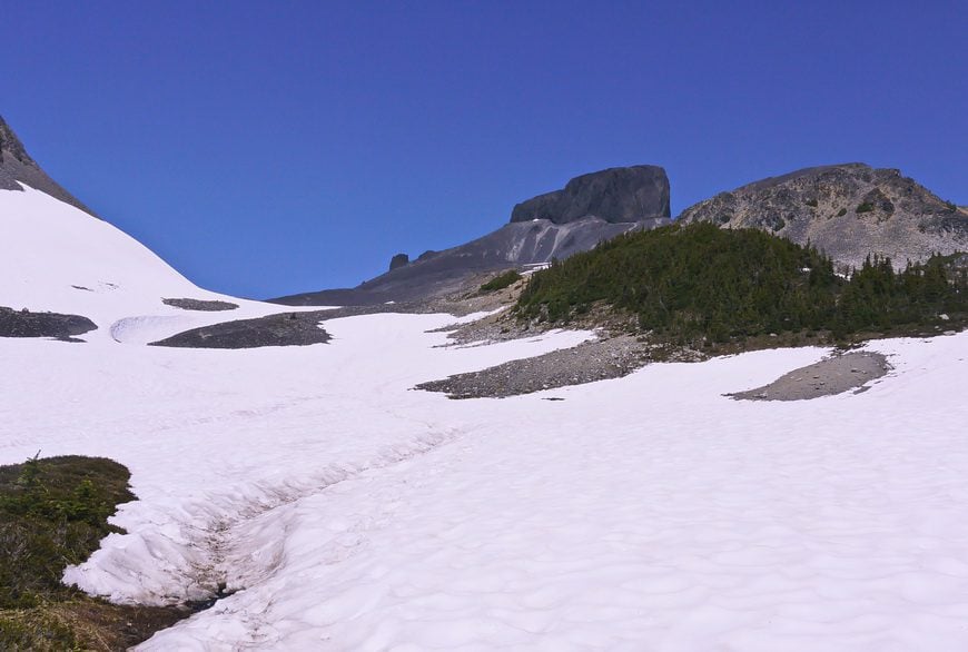
Snowfields on the way up the Black Tusk
Rainbow Mountains, Tweedsmuir Provincial Park
If you make it into the Chilcotin and you don’t mind hiking with nary a soul around, then this hike is for you. It’s a moderate hike climbing 300 metres over 8 kilometres. The scenery once you’re out of the trees is unreal – deep blue tarns and mountains in almost every colour of the rainbow.
It’s possible to continue off trail and even spend a night or two up here exploring. When we did it, we didn’t see a single hiker – only some horse-packers.
Read: A World-Class Hike in Tweedsmuir Provincial Park, BC
The Rainbow Range hike near Bella Coola is a winner
Iceline Trail, Yoho National Park
As one of the top day hikes in Canada, you can be assured of spectacular scenery once you’ve reached treeline.
You can do the hike as an up and back affair or as a loop. Weather may dictate your choices. Hike anywhere between 13 and 21 kilometres with a vertical gain in the order of 690 metres. The reward is a superb view of Takkakaw Falls – the second highest waterfall in Canada. As you hop across glacier-fed streams you’ll catch views of the Yoho Valley and Emerald Glacier.
It’s possible to extend the trip and either camp or stay at Stanley Mitchell Hut. If you do that I highly recommend some off-trail exploring in the President Range.
Read: Hiking the Spectacular Iceline Trail near Field, BC
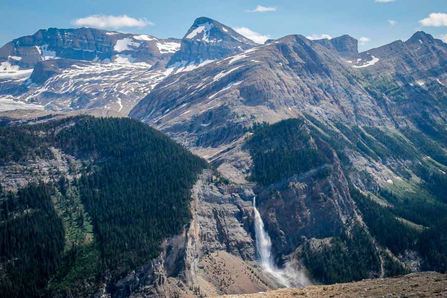
Great views of Takkakaw Falls from the Iceline Trail
Lake O’Hara trails, Yoho National Park – for premium hikes in Canada
The Lake O’Hara trails offer some of the most accessible, jaw-dropping mountain views in Canada. Although the area is just 11 kilometres in from the Trans-Canada Highway, most people take the school bus and the crux of your hike might just be nabbing a reservation. As of 2020 they are doing random drawings for seats. Check out the Parks Canada website for all the details.
You are best off overnighting in the area – either camping, staying at the Alpine Club of Canada Hut or trying to nab a reservation at the pricey Lake O’Hara Lodge. But then you have days’ worth of day hikes on your doorstep. I highly recommend the Alpine Circuit though even going to Lake Oesa or Lake McArthur are good choices.
Read: The Lake O’Hara Alpine Circuit, Yoho National Park
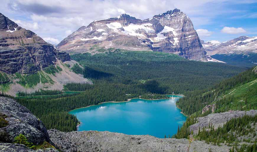
View from the Yukness Ledges
Alberta day hikes
Helen Lake, Banff National Park- one of the top wildflower hikes in Canada
It’s just 12 kilometres return to reach Helen Lake and the scenery is pretty darned amazing within a few kilometres of leaving the parking lot. Enjoy great views of Bow Lake and the Crowfoot Glacier once you’ve hiked about 50 minutes.
Some hikers will reach Helen Lake within 90 minutes. If you’ve got the time and energy continue climbing up to Cirque Peak. It’s a total of 1043 metres to summit the peak. Even if you go up to the ridge below the peak, the views are rewarding.
Helen Lake is very much worth visiting in wildflower season – one of the hot spots in the Rockies.
Read: The Fabulous Helen Lake Hike in Banff National Park
Looking down at Helen Lake
Aylmer Lookout, Banff National Park
The 23.4 kilometre Alymer Lookout Trail is a great early season hike to do in Banff National Park.
It’s easy hiking as far as the Aylmer Pass junction. At times there are some excellent Lake Minnewanka views. At the signed turnoff it’s time to start climbing. It’s another 4 kilometres and 570 metres of climbing to reach the lookout. But what a treat it is offering views up and down the length of Lake Minnewanka.
Allow 7 – 9 hours round-trip, depending on your pace. There are campsites along the shoreline of Lake Minnewanka through reservations are needed. This area is also known for its healthy bear population so don’t forget the bear spray.
Read: The Aylmer Lookout Hike in Banff National Park
Views up and down Lake Minnewanka
Prairie Mountain, Kananaskis Country
Prairie Mountain is my go to hike from Calgary – especially in the winter when I want a real workout with a view. It’s a stiff hike of 7.6 kilometres round-trip with a vertical gain of 726 metres. Once you break through treeline, the views of the prairies and the mountains are excellent. It’s a popular trail but a tough one. Allow 2.5 – 4 hours return.
Read: The Year Round Prairie Mountain Hike near Bragg Creek
Grand mountain scenery on the way down
Pocaterra Ridge, Kananaskis Country – one of the best larch hikes in Canada
If you want your heart to sing, do this 8.7 kilometre one way hike in September when the larches are ablaze in yellow. If you start at Highwood Pass (the top of the highest paved road in Canada) it’s a 950 metre elevation gain and a 640 metre loss to finish at the Little Highwood Pass parking lot.
The hike is best done as a shuttle and it’s easiest from Highwood Pass. Once you gain the high point it’s a long ridge walk above treeline with amazing views in all directions.
Read: The Fantastic Pocaterra Ridge Hike in Kananaskis
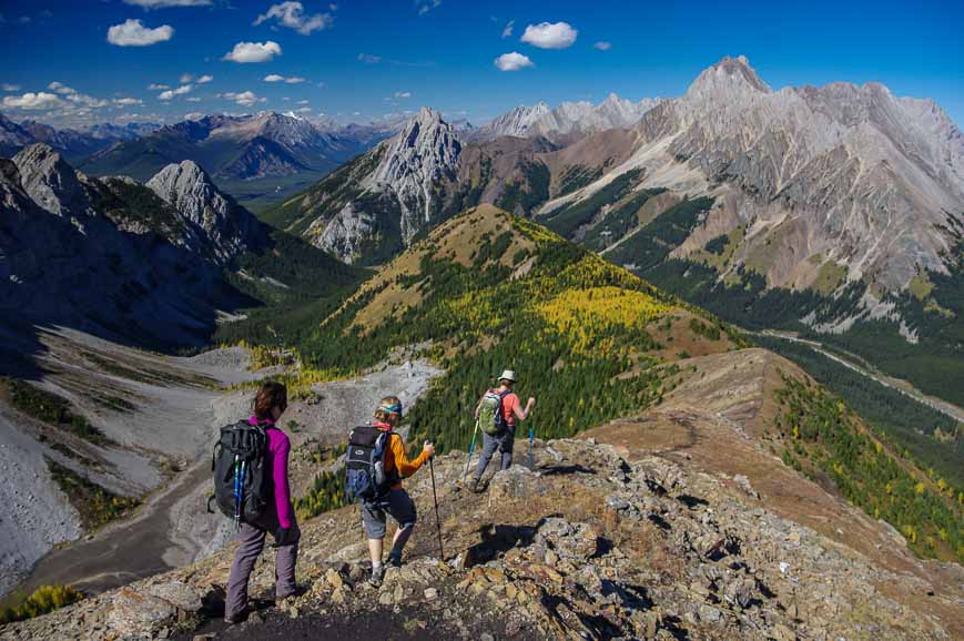
The Pocaterra Ridge hike off of Highwood Pass
Lake Agnes – Big Beehive Hike, Banff National Park
The Lake Agnes Teahouse is a very popular hike and destination. But rather than stop there, continue around Lake Agnes and climb up to the Big Beehive. You’ll be rewarded with great views of Lake Louise – on a far easier hike than Fairview Mountain – seen across the lake.
The hike is 10.3 kilometres return with an elevation gain of 540 metres.
Read: The Lake Agnes – Big Beehive Hike
Stellar views of Lake Louise from the Big Beehive in October
Crypt Lake, Waterton Lakes National Park
The Crypt Lake hike offers a variety of experiences you won’t find on other hikes in Canada. After crossing a narrow scree slope, you must climb a ladder, make your way through a 20 metre tunnel and then inch along a rocky trail with a steel cable for a handhold – with a drop-off on the other side that may scare some people. (It’s not as bad as it sounds.)
The 17.4 kilometre round-trip hike starts with a scenic boat ride to the trail head. Allow 5 to 7 hours to tackle the hike with its moderate 690 metres of elevation gain.
Read: The Crypt Lake Hike in Waterton Lakes
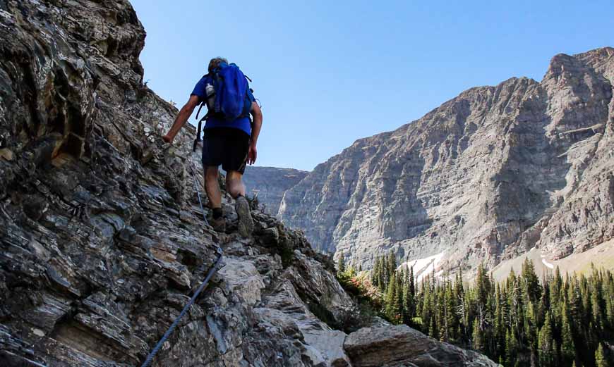
John hanging onto the steel cables on the Crypt Lake Trail – one of the top hikes in Canada
Turtle Mountain, Crowsnest Pass – one of the hikes in Canada where you might feel tension at the top
You won’t have a lot of company on the hike up Turtle Mountain and yet it’s well worth doing. Start in the town of Blairmore in the Crowsnest Pass area and follow the unmarked though obvious trail 3.1 kilometres one way to the summit of Turtle Mountain. This is where Canada’s second largest landslide occurred on April 29, 1903.
You still feel some tension on this hike as you look down at the carnage wrought by the Frank Slide. At some point the mountain will slide again, though there is monitoring equipment on top to provide a warning. Forget the threat and enjoy the views instead!
Read: 3 of the Best Hikes in the Crowsnest Pass Area
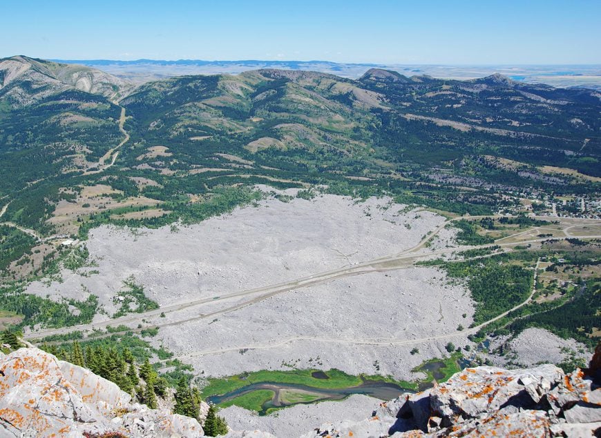
Looking at the Frank Slide from the top of Turtle Mountain
Table Mountain, Castle Provincial Park
For a hike that offers a lot of variety do the mostly steep hike up to flat-topped Table Mountain in Castle Provincial Park with its exceptional views of the prairies.
The hike is reportedly 10 kilometres return with approximately 700 metres of elevation gain. We made it to the summit in 90 minutes but I think the average time is closer to two hours. From the summit allow another couple of hours for wandering to the peak beyond Table Mountain. It’s easy hiking once on top with 360 degree views. I recommend poles for the descent.
Read: Alberta’s Fabulous Table Mountain Hike
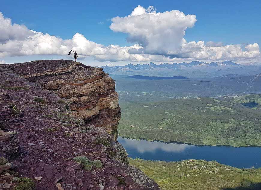
It’s worth the climb up Table Mountain to get this view
Saskatchewan day hikes
Boreal Trail, Meadow Lake Provincial Park
The Boreal Trail is Saskatchewan’s longest hiking trail – but most people don’t do the whole thing. Instead they bite off chunks of the trail that can be done in a day. If you’re with a group, even better as you can arrange a shuttle and cover more ground.
The trail showcases the beauty of the Boreal forest. I think it’s particularly pretty at the western end of the trail. Hike through lovely stands of birch trees, past the odd lake – and listen for the bird song. Some of the trail feels wild and remote – and some does not, especially any sections you share with the ATV crowd.
Check the Meadow Lake Provincial Park website before you go as some sections of the trail suffered significant damage in summer 2019.
Read: The Boreal Trail Hike in Meadow Lake Provincial Park
Starting the Boreal Trail at its western end in Meadow Lake Provincial Park
Grasslands National Park
You’ll find both front-country and backcountry hiking in Grasslands National Park down in southern Saskatchewan.
Front-country hikes are accessible and you don’t need strong navigation skills – just common sense. Some of the trails to consider include 70 Mile Butte Trail which gets you to the highest point in the park. It’s particularly lovely – in its quiet way – with loads of grasses and lichen-covered rocks about.
Two other choices in the west block of the park include the Two Trees Trail and the Riverwalk Trail. Fall is lovely as its cooler and the bugs are gone. Night skies here are amazing.
Read: Hiking in Grasslands National Park, Saskatchewan
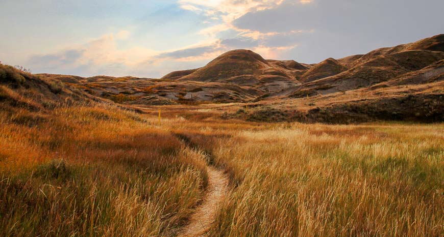
Beautiful prairie skies and colours in Grasslands National Park in the fall
Manitoba day hikes
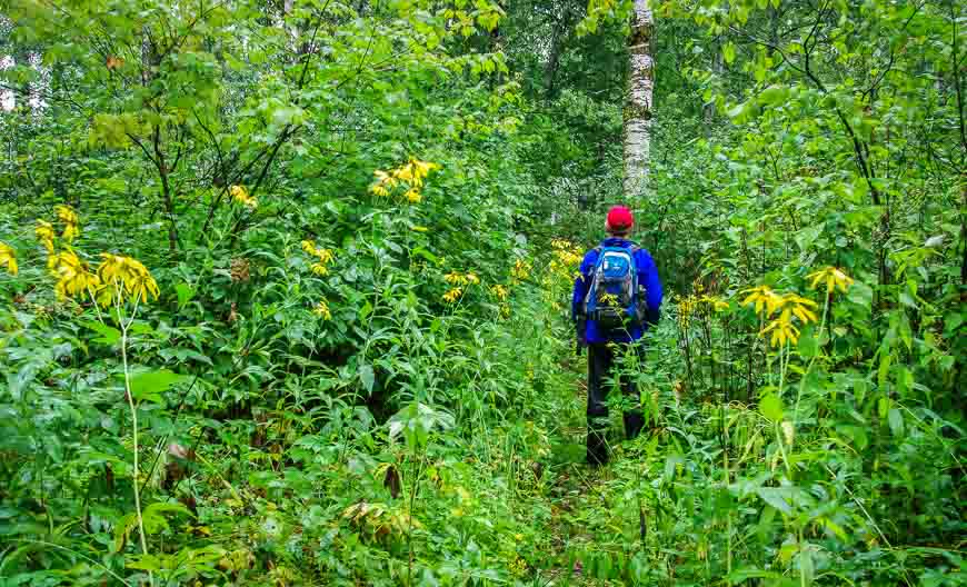
Gorge Creek Trail, Riding Mountain National Park
Called one of the top hikes in Riding Mountain National Park, this trail will probably surprise you with its range of ecosystems. Hike up and down the Manitoba escarpment – keeping an eye out for poison ivy and black bears.
Enjoy swaths of wildflowers as tall as a human, views of the plains and a forest so lush you may think you’re in another country and not a prairie province.
Allow 3.5 – 5 hours to hike the 12.8 kilometre return trail with its 300 metres of elevation gain and loss.
Read: Gorge Creek Trail Hike, Riding Mountain National Park
Walking through tall wildflowers on the Gorge Creek Trail
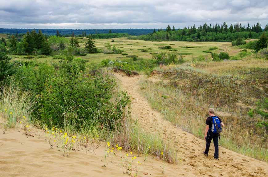
Spirit Sands hike, Spruce Woods Provincial Park
Near Brandon Manitoba is Spruce Woods Provincial Park, the home of Manitoba’s only sand dunes – located where the Boreal forest meets the Assiniboine River.
Allow three to four hours to explore all the trails that make up the Spirit Sands – Devil’s Punch Bowl combination. While the hiking is easy on the Spirit Sands trail, it can get very hot by noon on a summer day. All the hiking trails could be covered in as little as 90 minutes but at a meandering pace it could easily take three hours.
This is a great place to take kids. If you were driving the Trans-Canada Highway it would be a fine stop.
Read: The Spirit Sands Hike in Spruce Woods Provincial Park, Manitoba
Hiking the Spirit Sands Trail
Ontario day hikes
Top of the Giant, Sleeping Giant Provincial Park – one of the hikes in Canada with an airy view
If you want to enjoy superb views of Lake Superior do the 24 kilometre return hike to the Top of the Giant. Even though it’s a long hike, there is only 290 metres of elevation gain. The first 8 kilometres are completely flat so you can knock them off in a couple of hours.
Interestingly, when you reach the Top of the Giant you’re still 45 minutes away from the high point. Be sure to go to the very end of the hike so you get the thrilling view over the cliff. At this point you’re at one of the highest points in Ontario overlooking the largest freshwater lake in the world by area. It’s quite a sight!
The hike is easily accessible from Thunder Bay as a day trip or you can camp in the park.
Read: The Top of the Giant Hike in Northwest Ontario
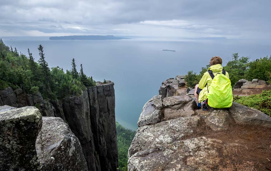
Superb view of Lake Superior from Top of the Giant hike
South Headland Trail, Pukaskwa National Park – one of the hikes in Canada that packs a punch in a short distance
The Southern Headland Trail is a mere 2.2 kilometres long but it packs a punch over its short length. Enjoy boardwalks, views of Lake Superior and beautiful beaches. You can knock it off in under an hour.
For a full-day hike, head to White River Canyon and Suspension Bridge on the Coastal Trail that runs for 60 kilometres. This is the easiest part of the longer hike and very enjoyable. Boardwalks, some lovely flat stretches through woods, and beautiful Playter Harbour are some of the highlights between the parking lot and the suspension bridge.
Read: A Hike on the Southern Headland Trail in Pukaskwa Park
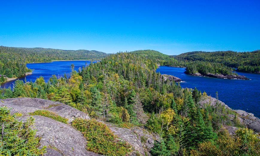
The start of the views on the Southern Headland Trail, Pukaskwa National Park
Bruce Trail in Bruce Peninsula National Park
For a hike on the most scenic section of the 894 kilometre Bruce Trail, head to Bruce Peninsula National Park. Look for the 21 kilometre section of the Bruce Trail that jogs through the park.
Either arrange a shuttle or do out and back hikes, perhaps over a few days. The trail often runs close to the cliff edge where you can look down at an otherworldly colour of turquoise blue water. Don’t miss a stop at the Grotto and Indian Head Cove. It’s also worth hiking on the sharply pointed rocks to the fantastic lookout of Overhanging Rock.
This park is far busier that when I visited, so aim to come early or visit on a weekday. There are some really lovely campsites too.
Read: Highlights of Hiking the Bruce Trail in Bruce Peninsula NP

The Bruce Trail in Brice Peninsula National Park
Quebec day hikes
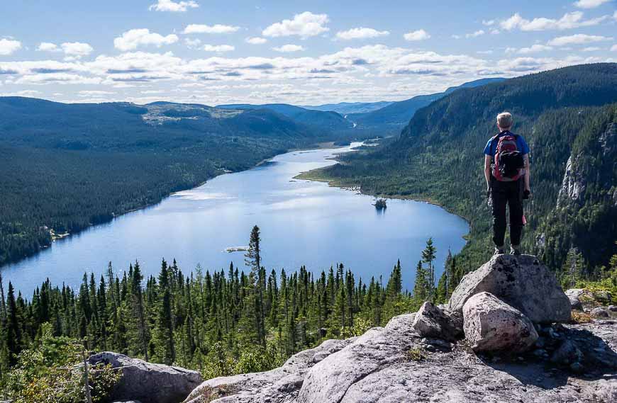
Mont Albert in the Chic Choc Mountains
This is one tough but rewarding hike. Over 17.4 kilometres climb 885 metres on a trail that feels like it’s on the steep setting of a Stair Master. Hike up the short, steep section so that once you reach the massive plateau you’ve got views for hours and a slightly easier descent.
If you’re lucky you might see a caribou or two. I was not. But still the hike delivers fabulous scenery that includes tundra and waterfalls. There is a shelter on top if a storm moves in.
Read: Hiking to the Summit of Le Mont Albert in Quebec
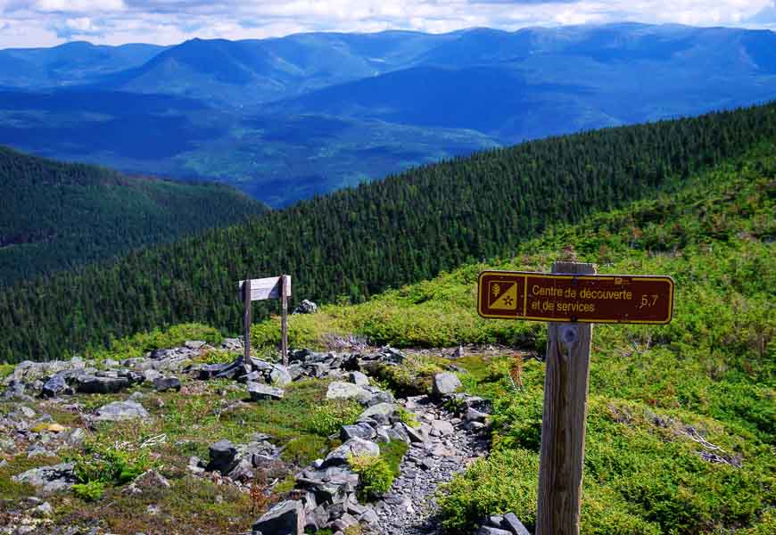
The first views from the top of Le Mont Albert
Les Graves, Forillon National Park
Follow the coast on Les Graves – a 15.2 kilometre out and back hike that takes you by quiet coves, along a stretch of the Appalachian Trail to ultimately end at the Cape Gaspé lighthouse. Along the way stop to enjoy the beaches and admire the wildflowers. Find a bench and enjoy the sweeping views.
Allow up to a full day depending on how many stops you make.
Read: A Coastal Hike in Forillon National Park, Quebec
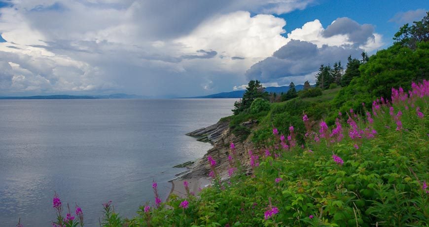
Beautiful scenery on the Coastal Trail in Forillon National Park
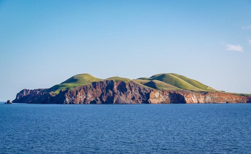
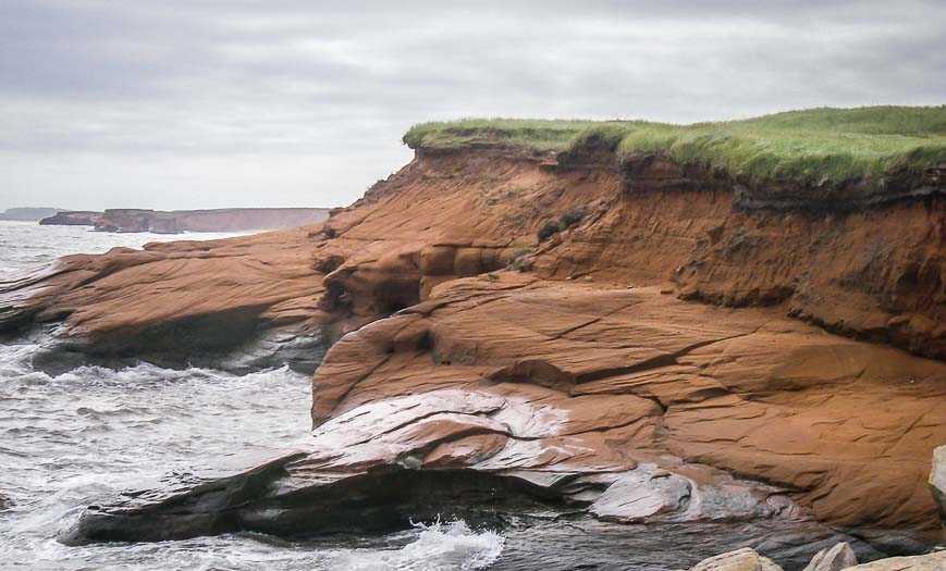
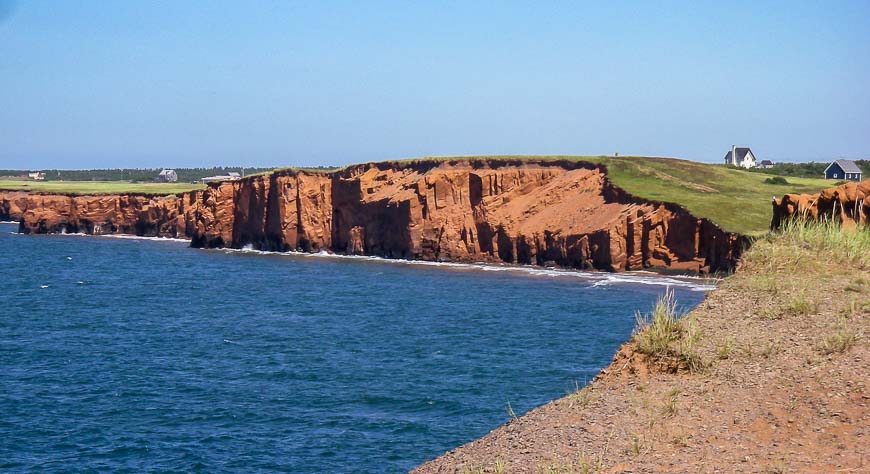
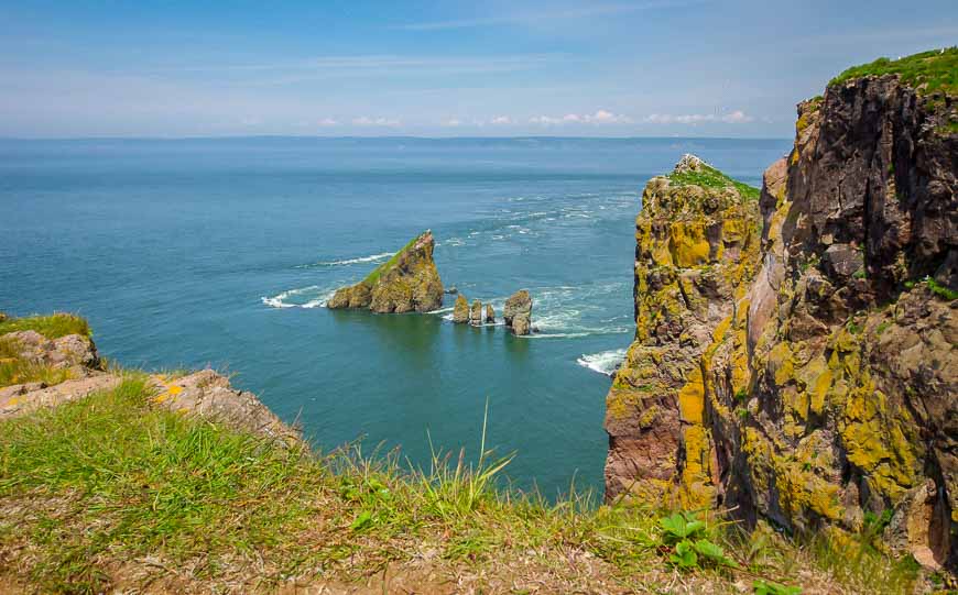
Mingan Archipelago National Park
Head to Quarry Island via a boat trip (you can charter or check for a guided tour) and hike one of four trails. The longest – Les Cypripèdes is a 10.8 kilometre loop while the shortest is a mere 0.6 kilometres. Be sure to hike the shore trail as a loop via Les Falaises so you can walk around the natural monoliths made of rock. They are like nothing I have ever seen and there is nowhere else in Canada where the monoliths are in such abundance.
Read: A Trip to Mingan Archipelago National Park in Quebec
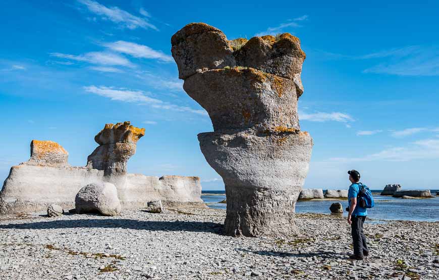
Superb hiking on the coastal trail on Quarry Island
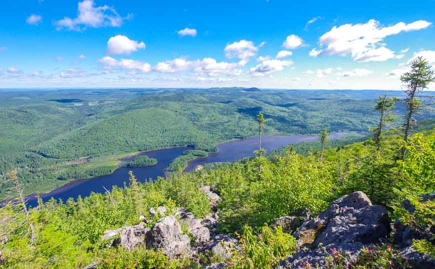
Trail of the Summits, Charlevoix Area – one of the hikes in Canada that’s great for blueberries
After hiking 4 kilometres in on a flat road you arrive at the Squirrel Hut – the first stop on the Charlevoix Traverse. The Trail of the Summits is accessible from the hut and offers stupendous views of the hilly area.
The full Trail of the Summits hike is 17.6 kilometres long though the main trail is just 7.2 kilometres return. Trails branch off the main trails to reach the various summits including Sommet de la Grive, Sommet du Mont du Lac a l’Ecluse, Sommet de PV Coulee and Sommet de PV Pic de l’Aigle. You can pick and choose what side trails you want to do, based on how much time you have.
Read: Hut to Hut hiking on the Charlevoix Traverse
Great views & lots of blueberries on the Trail of the Summits
New Brunswick day hikes
Mount Sagamook, Mount Carleton Provincial Park – one of the hikes in Canada where you see a lot of trees!
If you have ever wanted to see 10 million trees from one perch, the Mount Sagamook trail is the one to do. It’s just 5.8 kilometres as a loop with a few short side trails to viewpoints. It’s steep but so worth it for the views.
Chances are you’ll have the trail to yourself – and all the blueberries you can eat – at least in late summer.
Read: Sagamook Peak Hike, Mount Carleton Provincial Park
Gorgeous views on the Mount Sagamook hike
The Hole in the Wall Hike, Grand Manan Island
Grand Manan Island is one of three Fundy Isles off the New Brunswick coast. Its home to several hikes but perhaps the most interesting one is the easy hike to the Hole in the Wall on the east side of the island.
It’s an easy family-friendly trail that is only 3.1 kilometres long. While you can get to it from roads in a campground, take the trail that follows the coast, even if it is slow-going at times.
Pay to park in the Hole in the Wall Park and pick up one of their maps. Enjoy excellent views of fishing weirs and of the Bay of Fundy. If you’re lucky you might spot seals or a whale.
Read: A Visit to Grand Manan Island, New Brunswick
The Hole in the Wall hike on Grand Manan Island
Nova Scotia day hikes
Cape Split, Cape Split Provincial Park
Although the hike out to Cape Split may be underwhelming at times, it’s worth it just to see Cape Split. The approximate 16 kilometre hike (probably high) will take you 2.5 – 5 hours depending on your pace and how long you stay out at the end.
Cape Split at the tip of the Blomidon Peninsula, offers stunning Bay of Fundy views and loads of bird action. In the spring the wildflowers are excellent too.
Look for lots of side trails running off the main trails to lookouts but be very wary as the drop-offs can be extreme.
Read: One of Nova Scotia’s Great Day Hikes: The Hike to Cape Split
Views at the end of the hike to Cape Split
Hikes in Canada – The Port Joli Head Loop, Kejimkujik National Park
The 8.7 kilometre Port Joli Head loop trail is a gem. It takes you to the coast via a boardwalk and gravel paths through a forest of stunted balsam fir and white spruce. Wildflowers are outstanding, especially the clumps of pitcher plants and wild iris. Orchids grow here too.
Keep an eye out for black bears. I came upon a mom and her two cubs when I was hiking alone – without bear spray. Around Harbour Rocks look for basking seals and seabirds. Allow a half-day to do the whole trail but it’s worth lingering and bringing a picnic.
Read: Hiking in Kejimkujik National Park – The Seaside Edition
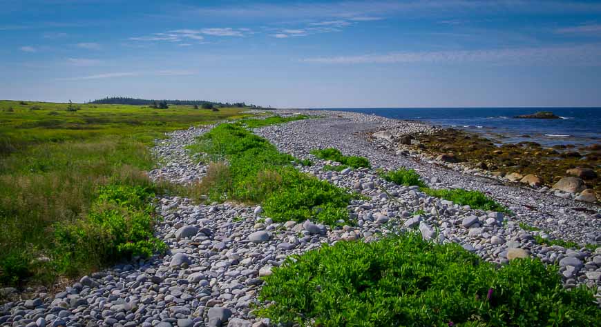
Beautiful coastal walking in Seaside Kejimkujik National Park
Prince Edward Island day hikes
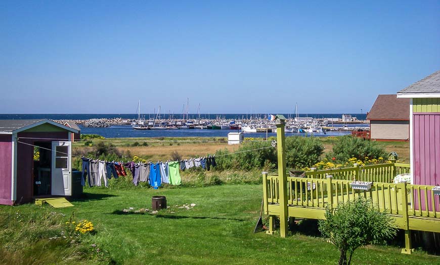
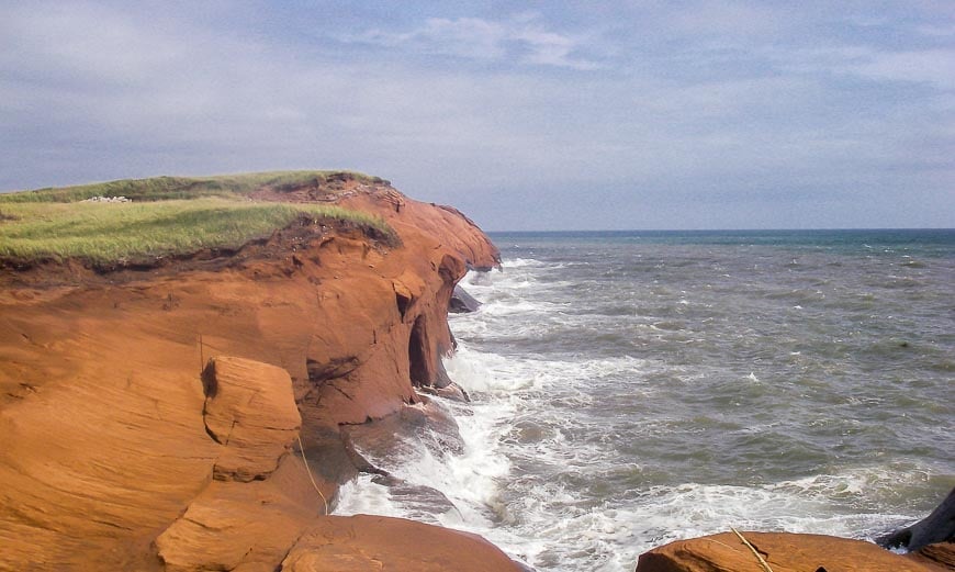
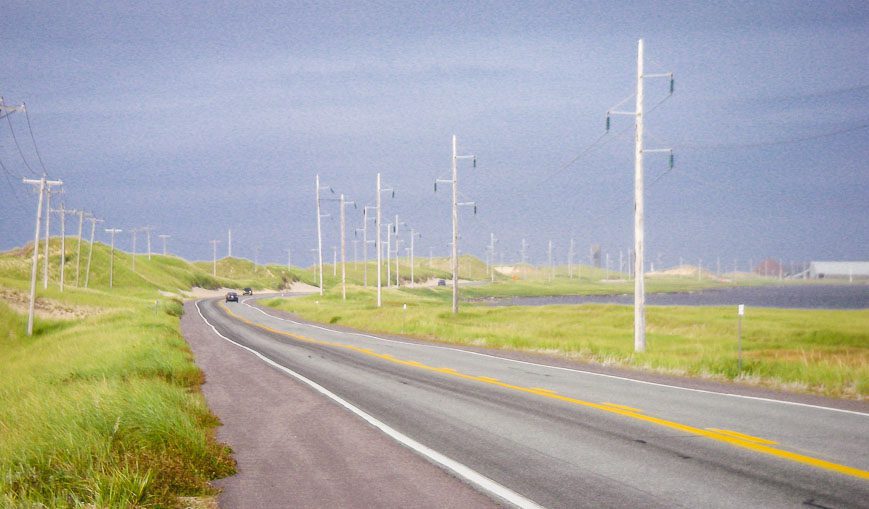
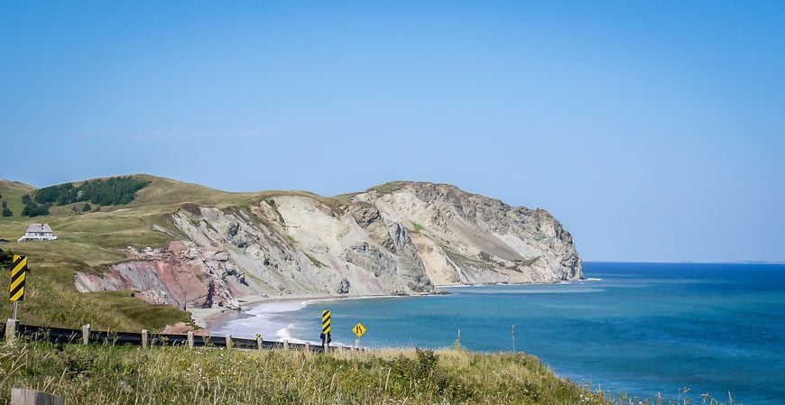
Greenwich section of Prince Edward Island National Park
It’s just 4.5 kilometres return to hike to the Greenwich Dunes and beach from the Interpretation Centre. That includes a section on a beautifully built 0.75 km boardwalk. Once you arrive at Greenwich Beach you can continue walking for about 6 kilometres.
This area isn’t particularly busy but it’s lovely. Don’t forget the bathing suits or a picnic.
Read: Boardwalks, Beaches & Sand Dunes: Greenwich: PEI National Park
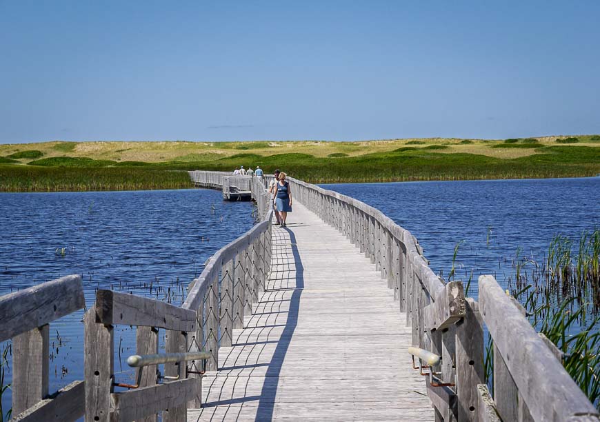
Lovely boardwalk section in PEI National Park
Newfoundland day hikes
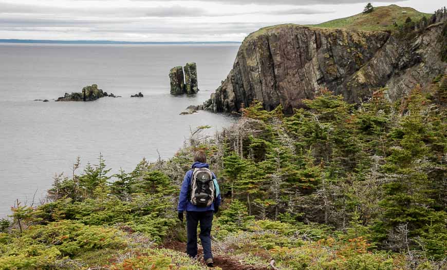
Sugarloaf Path, East Coast Trail – one of the best coastal hikes in Canada
The East Coast Trail is one of Canada’s premiere long distance hikes. But it’s broken into sections and each section can be done as a day trip. One of the best one day sections is the 8.9 kilometre Sugarloaf Path. We hiked it from Logy Bay all the way back to downtown St. John’s via Quidi Vidi Village.
Enjoy fantastic bird life, rugged coastal scenery and icebergs in season.
Read: Hiking the Sugarloaf Path on the East Coast Trail
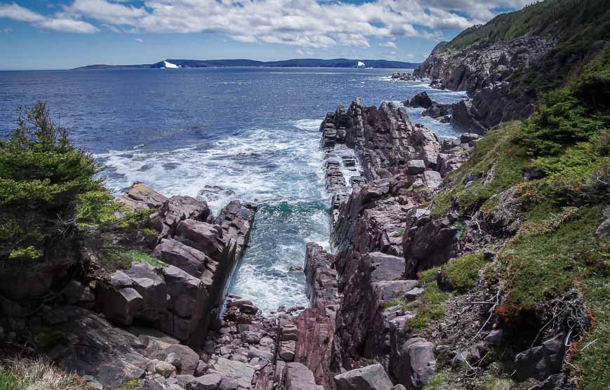
Scenery from the Sugarloaf Path – – one of the more interesting and diverse hikes in Canada
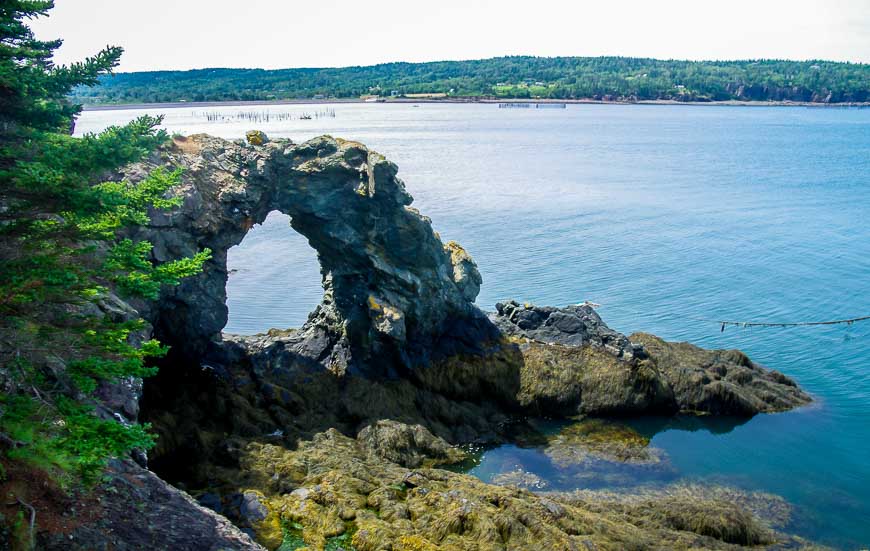
Skerwink Trail, Trinity Area, Bonavista Peninsula
The Skerwink Trail is a 5.3 kilometre loop hike that offers fantastic coastal scenery. The well-built trail takes you by sea stacks, sea caves and arches, past capelin beaches and onto a promontory with a bench and a view where you might spot a minke whale or an errant iceberg.
Signage is excellent. You only need 1.5 to 2.5 hours to do the whole trail
Read: Hiking the Skerwink Trail near Trinity, Newfoundland
Gorgeous hiking on the Skerwink Trail – one of the exceptional hikes in Canada
Hikes in Canada – Alexander Murray Trail in King’s Point
Do you like stairs? If your answer is no then give this hike a pass. But if you can handle the thought of 2,200 stairs then you will be much rewarded at the top – called Haypook. In June we could see icebergs off in the distance. It’s a great trail that takes 3 – 5 hours – and perfect for breaking up a drive if you’re on your way to Deer Lake.
Read: Hiking the Alexander Murray Trail in King’s Point, Nfld
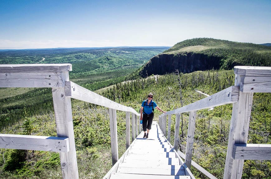
My friend Judy thinking enough already with these stairs
Hikes in Canada – Gros Morne Mountain in Gros Morne National Park
If you only have time for one hike in the park, make it this one. It’s a full day hike covering 16 kilometres with 800 metres of elevation gain. But the rewards are sublime ….on a clear day. Enjoy views of Ten Mile Pond, the Long Range Mountains, and Arctic tundra. Look for animals like moose and woodland caribou.
Again there’s a steep section of stairs – 177 of them – on the descent. Camping is possible at the Ferry Gulch Campsite.
Read: A Hike to the Summit of Gros Morne Mountain
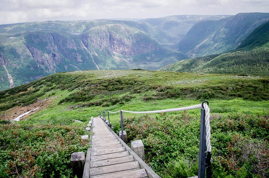
Views over to the Long Range Traverse from Gros Morne Mountain – one of the top hikes in Canada
Other day hikes in Canada either on my wish list or I’ve done
- L’acropole des draveurs is reportedly an excellent day hike in Parc des Hautes-Gorges in Charlevoix, Quebec
- A section of the Juan de Fuca trail on Vancouver Island
- Kwai Lake trail in Strathcona Provincial Park, BC
- Stawamus Chief in Squamish
- Kokanee Glacier Trail near Nelson
- The Skyline Trail in Cape Breton Highlands National Park
- Green Gardens Coastal Trail in Gros Morne National Park
- Rim Trail, Cathedral Provincial Park, BC
- Sunshine Meadows, Banff National Park
- Centennial Ridge, Kananaskis Country, Alberta
Click on the photo to bookmark to your Pinterest boards.

The post 35 Top Day Hikes in Canada – Personally Tested appeared first on Hike Bike Travel.